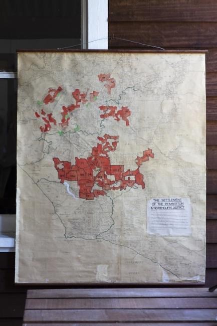
Map of Group Settlement

Map

Each red shape on this map of the South West carries a number which identifies each Group Settlement block. Migrants arriving to be part of the Group Settlement Scheme were allocated to a particular block. Some were luckier than others. The quality of the land was inconsistent, and some areas should never have been allocated for farming. The history of the Group Settlement Scheme in Pemberton, which began in 1923, contributes to a story of hardship told in many of the historical collections in the South West.

Available at:

Pemberton Pioneer Museum

Originally known as Big Brook, the town of Pemberton began as the site of a saw-mill built in 1912. This Museum tells the history of the timber industry in the local forests through its interesting...

Address:

29 Brockman Street
Pemberton WA 6260
Australia

Open Hours
7 days

More from the Pemberton Pioneer Museum

The box proudly proclaims “Bunn’s Hops are grown on the famous Waterfall Hop Gardens of Pemberton”. These Hop Gardens are where Karri Valley Resort now stands. The hop farm was started here in the...

You might think that the introduction of chainsaws in 1952 would have radically changed the timber-felling industry. However, the early chainsaws did not necessarily make the job quicker, easier or...

While you're in the area

Filter
Moons Crossing
Attraction
Moons Crossing
Moons Crossing is a beautiful section of the Warren River just outside...
Moon Crossing Road, Northcliffe, WA 6262
Pump Hill Farm Cottages
Accommodation
Pump Hill Farm Cottages
Pump Hill Farm Cottages is not just a place to stay - it's a whole...
129 Pump Hill Road, Pemberton, WA 6260
Yeagarup Hut
Accommodation
Yeagarup Hut
Yeagarup Hut is an initiative by the Department of Parks and Wildlife and...
Ritter Road, Yeagarup, WA 6260
10 Chains
Food and Drink
10 Chains
Set amongst the spectacular Karri forests of Pemberton, this humble family...
89 Charlie Road, Crowea, WA 6262